Fitxategi:360-degree Panorama of the Southern Sky edit.jpg
Nabigaziora joan
Bilaketara joan


Aurreikuspen honen neurria: 800 × 243 pixel. Bestelako bereizmenak: 320 × 97 pixel | 640 × 194 pixel | 1.024 × 311 pixel | 1.280 × 389 pixel | 2.560 × 778 pixel | 15.204 × 4.620 pixel.
Jatorrizko fitxategia (15.204 × 4.620 pixel, fitxategiaren tamaina: 33,95 MB, MIME mota: image/jpeg)
| Warning | The original file is very high-resolution. It might not load properly or could cause your browser to freeze when opened at full size. |
|---|
Laburpena
| Deskribapena |
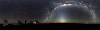
Deutsch: Die Milchstraße wölbt sich über dieses 360°-Panorama des Nachthimmels, fotografiert von der Paranalplattform, Sitz des Very Large Telescopes der ESO. Über dem gerade aufgehenden Mond scheint das Zodiaklicht, während die Milchstraße sich über den Himmel auf der gegenüberliegenden Seite des Observatoriums streckt. Auf der rechten Bildseite und unterhalb des Milchstraßenbogens sind zwei unserer galaktischen Nachbarn, die Magellanschen Wolken, zu sehen. Alle geöffneten Teleskopkuppeln des weltweit leistungsfähigsten erdgebundenen astronomischen Observatoriums können im Bild erkannt werden: Die vier kleineren 1,8 Meter-Hilfsteleskope, welche gemeinsam als Interferometer genutzt werden können, sowie die vier riesigen 8,2 Meter-Unit-Teleskope. Die Fotografie wurde aus 37 Einzelbildern zusammengesetzt, welche mit einer Belichtungszeit von ca. 30 Minuten in den frühen Morgenstunden aufgenommen wurden. English: The Milky Way arches across this 360-degree panorama of the night sky above the Paranal platform, home of ESO’s Very Large Telescope. The Moon is just rising and the zodiacal light shines above it, while the Milky Way stretches across the sky opposite the observatory. To the right in the image and below the arc of the Milky Way, two of our galactic neighbors, the Small and Large Magellanic Clouds, can be seen. The open telescope domes of the world’s most advanced ground-based astronomical observatory are all visible in the image: the four smaller 1.8-metre Aŭiliary Telescopes that can be used together in the interferometric mode, and the four giant 8.2-metre Unit Telescopes. The image was made from 37 individual frames with a total exposure time of about 30 minutes, taken in the early morning hours. Español: Los arcos de la Vía Láctea a través de este panorama de 360 grados del cielo nocturno por encima de la plataforma de Paranal, Very Large Telescope de la casa de ESO. La luna sólo está aumentando y la luz zodiacal brilla por encima de él, mientras que los tramos de la vía Láctea en el cielo enfrente del Observatorio. A la derecha en la imagen y debajo del arco de la vía Láctea, dos de nuestros vecinos galácticos, las pequeñas y grandes nubes de Magellanic, pueden verse. Las cúpulas del telescopio abierto de Observatorio Astronómico terrestre más avanzado del mundo son visibles en la imagen: los cuatro telescopios más pequeños de Aŭiliary 1,8 metros que pueden utilizarse juntos en el modo interferométrico y los cuatro telescopios gigantes de unidad de 8,2 metros. La imagen fue hecha de 37 fotogramas individuales con un tiempo total de exposición de unos 30 minutos, en la madrugada. Français : La voie lactée parcours ce panorama à 360° du ciel nocturne pris sur la plate forme du Paranal, occupée par le Very Large Telescope de l'ESO}. La lune vient de se lever et la lumière zodiacale est visible juste au dessus d'elle. Sur la droite, sous la voie lactée, on distingue nos deux compagnons galactiques, les Nuages de Magellan. L'observatoire est constitué de 8 dômes, tous visibles ici: Les quatre petits abritent les télescopes auxiliaires de 1,8 mètre qui peuvent être utilisés en mode interférométrique. Les quatre grands dômes abritent quatre télescopes géants de 8,2 mètres d'ouverture. Image réalisée en assemblant 37 clichés réalisés dans les petites heures du matin. |
| Data | Edited on 2010ko apirilaren 1ea, 16:53 (UTC) |
| Jatorria | Norberaren lana, ondorengo hau(ek) oinarri hartuta: 360-degree Panorama of the Southern Sky edit.jpg and 360-degree Panorama of the Southern Sky.jpg |
| Egilea |
|
| Beste bertsioak |
|
| 360° | View in 360° panoramic viewer
|
|---|
| Kameraren kokapena | | Irudi hau eta gehiago beraien kokapenekin hurrengo lekuetan: OpenStreetMap |
|---|
| This is a retouched picture, which means that it has been digitally altered from its original version. Modifications: noise reduction to ground only. The original can be viewed here: 360-degree Panorama of the Southern Sky.jpg:
|
Lizentzia
This media was created by the European Southern Observatory (ESO).
Their website states: "Unless specifically noted, the images, videos, and music distributed on the public ESO website, along with the texts of press releases, announcements, pictures of the week, blog posts and captions, are licensed under a Creative Commons Attribution 4.0 International License, and may on a non-exclusive basis be reproduced without fee provided the credit is clear and visible." To the uploader: You must provide a link (URL) to the original file and the authorship information if available. | |
This file is licensed under the Creative Commons Attribution 4.0 International license.
| |
Assessment
|
Jatorrizko igoera erregistroa
This image is a derivative work of the following images:
- 360-degree Panorama of the Southern Sky.jpg licensed with Cc-by-3.0, Eso
- 2009-11-09T14:15:03Z Originalwana 15204x4620 (18891119 Bytes) {{Information |Description={{en|1=The [[Milky Way]] arches across this 360-degree [[panorama]] of the night sky above the Paranal platform, home of ESO’s [[:Category:Very Large Telescope|Very Large Telescope]]. The image wa
Uploaded with derivativeFX
Fitxategiaren historia
Data/orduan klik egin fitxategiak orduan zuen itxura ikusteko.
| Data/Ordua | Iruditxoa | Neurriak | Erabiltzailea | Iruzkina | |
|---|---|---|---|---|---|
| oraingoa | 19:30, 24 abuztua 2010 | 15.204 × 4.620 (33,95 MB) | wikimediacommons>LobStoR | Reverted to version as of 03:58, 12 August 2010 -- revert to version the server can handle |
Fitxategiaren erabilera
Fitxategi hau darabil ondorengo orri honek: