Fitxategi:Ancient Orient.png
Nabigaziora joan
Bilaketara joan


Aurreikuspen honen neurria: 800 × 516 pixel. Bestelako bereizmenak: 320 × 206 pixel | 640 × 413 pixel | 1.024 × 661 pixel | 1.280 × 826 pixel | 2.560 × 1.652 pixel | 4.365 × 2.816 pixel.
Jatorrizko fitxategia (4.365 × 2.816 pixel, fitxategiaren tamaina: 10,18 MB, MIME mota: image/png)
Laburpena
| Deskribapena |
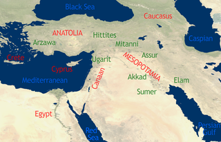
English: See Image:Orient 27 43 22 55 blank map.png for a blank map.
self-created in November 2004 on the basis of the 2002 NASA Blue Marble image.[1] |
| Data | 2004ko azaroaren 15a (Jatorrizko igoera-data) |
| Jatorria | This compound image uses free material land_shallow_topo_east.tif from NASA Visible Earth (formerly "Blue Marble") and world.200407.3x21600x21600.C1.png from JULY, BLUE MARBLE NEXT GENERATION |
| Egilea | Dbachmann and Cush at en.wikipedia |
Lizentzia
For the current map
| This work has been released into the public domain by its author, Cush. This applies worldwide. Estatu batzuetan beharbada hori ez da legez posible izango. Halakoetan: |
For the previous map
| This work has been released into the public domain by its author, Dbachmann at ingelesa Wikipedia. This applies worldwide. Estatu batzuetan beharbada hori ez da legez posible izango. Halakoetan: Dbachmann grants anyone the right to use this work for any purpose, without any conditions, unless such conditions are required by law. |
Jatorrizko igoera erregistroa
The original description page was here. All following user names refer to en.wikipedia.
- 2004-11-15 08:40 Dbachmann 429×274×8 (213130 bytes) {{PD}}
Fitxategiaren historia
Data/orduan klik egin fitxategiak orduan zuen itxura ikusteko.
| Data/Ordua | Iruditxoa | Neurriak | Erabiltzailea | Iruzkina | |
|---|---|---|---|---|---|
| oraingoa | 15:34, 22 urria 2010 | | 4.365 × 2.816 (10,18 MB) | wikimediacommons>Cush | Enhanced and enlarged version with city names and locations. Unfortunately the map had to be scaled to 88% of the original (due to size constraints on WP) so that the city labels are a little blurred. |
Fitxategiaren erabilera
Fitxategi hau darabil ondorengo orri honek: