Fitxategi:Carpathians-satellite.jpg
Nabigaziora joan
Bilaketara joan


Aurreikuspen honen neurria: 624 × 599 pixel. Bestelako bereizmenak: 250 × 240 pixel | 500 × 480 pixel | 800 × 768 pixel | 1.066 × 1.024 pixel | 2.133 × 2.048 pixel | 2.625 × 2.521 pixel.
Jatorrizko fitxategia (2.625 × 2.521 pixel, fitxategiaren tamaina: 2,6 MB, MIME mota: image/jpeg)
Laburpena
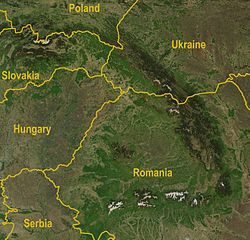
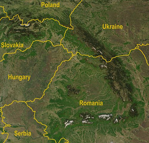
| Deskribapena | A satellite map of the Carpathians |
| Data | |
| Jatorria |
http://visibleearth.nasa.gov/view_rec.php?id=5348
|
| Egilea | Jeff Schmaltz, MODIS Rapid Response Team, NASA/GSFC |
| Beste bertsioak | Image:Karpaty zdjęcie satelitarne.jpg |
Lizentzia
| This file is in the public domain in the United States because it was solely created by NASA. NASA copyright policy states that "NASA material is not protected by copyright unless noted". (See Template:PD-USGov, NASA copyright policy page or JPL Image Use Policy.) | ||
 |
Warnings:
|
Fitxategiaren historia
Data/orduan klik egin fitxategiak orduan zuen itxura ikusteko.
| Data/Ordua | Iruditxoa | Neurriak | Erabiltzailea | Iruzkina | |
|---|---|---|---|---|---|
| oraingoa | 14:36, 30 abuztua 2009 | | 2.625 × 2.521 (2,6 MB) | wikimediacommons>Qorilla | Better resolution, yellow country names |
Fitxategiaren erabilera
Fitxategi hau darabil ondorengo orri honek: