Fitxategi:Flag map of the world.svg
Nabigaziora joan
Bilaketara joan


SVG fitxategi honen PNG aurreikuspenaren tamaina: 800 × 400 pixel. Bestelako bereizmenak: 320 × 160 pixel | 640 × 320 pixel | 1.024 × 512 pixel | 1.280 × 640 pixel | 2.560 × 1.280 pixel | 2.400 × 1.200 pixel.
Jatorrizko fitxategia (SVG fitxategia, nominaldi 2.400 × 1.200 pixel, fitxategiaren tamaina: 6,49 MB)
Laburpena
| Deskripzio |
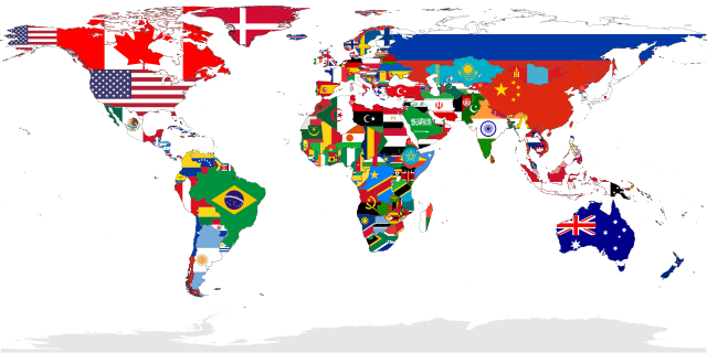
Deutsch: Eine Karte, die alle UN-Staaten mit ihrer Flagge zeigt. Das Gebiet der Westsahara ist grau eingefärbt, weil kein UN-Staat dieses Gebiet repräsentiert.
English: A map showing the flags of the world, in equirectangular projection. The countries shown are the members of the United Nations. Western Sahara is in light grey because it is considered to be a Non-Self-Governing Territory with no administration (source), therefore there is no UN member state flag to represent that place.
Español: Un mapa que muestra las banderas del mundo, en proyección equirrectangular. Los países que se muestran son miembros de las Naciones Unidas. El Sáhara Occidental está en gris claro porque se considera un territorio no autónomo sin administración, por lo tanto, no hay una bandera de un estado miembro de la ONU para representar ese lugar.
Français : Carte montrant les drapeaux du monde. Projection équirectangulaire. Les drapeaux présents correspondent aux membres des nations unies. En conséquences le sahara occidental est en gris, car considéré par l'ONU comme une territoire sans gouvernement autonome.
Українська: Мапа відображає всі країни світу, площі яких заповнені кольорами їхніх прапорів.
中文(繁體):本圖顯示的是全球聯合國會員國國家的國旗圖像,以全景圖方式顯示。非聯合國會員國的國家,不會在此圖中顯示其國旗。 |
| SVG genesis | handi Fitxategi hau (bektore-irudia) hau Adobe Illustrator-ekin sortu da . and with Inkscape. |
| Data | |
| Jatorria | Norberak egina |
| Sortzailea | |
| Georeferencing | If inappropriate please set warp_status = skip to hide. |
| Beste bertsioak |
Derivative works of this file: |
Assessment
|

Deutsch: Dieses Bild wurde als Bild der Woche auf der tschechischen Wikipedia für die 17 Woche ausgewählt, 2018. English: This image was selected as a picture of the week on the Czech Wikipedia for 17th week, 2018. Français : Cette image est sélectionnée en tant qu’image de la semaine sur la Wikipédia Tchèque pour la 17e semaine de 2018. Italiano: Questa immagine è stata selezionata come Immagine della settimana su Wikipedia in ceco per la XVII settimana del 2018. Македонски: Сликава е избрана за слика на неделата на чешката Википедија за XVII недела од 2018 година. Русский: Эта иллюстрация была выбрана изображением недели в чешском разделе «Википедии» для недели номер 17 2018 года. Українська: Ця ілюстрація була вибрана зображенням тижня в чеському розділі «Вікіпедії» для тижня номер 17, 2018 року. |

|
This image has been assessed under the valued image criteria and is considered the most valued image on Commons within the scope: Flag maps of the world. You can see its nomination here. |
Lizentzia
| Nik, lan honen egile eskubideen jabeak, lan hau domeinu publikoan jartzen dut. Mundu osoan du eragina honek. Estatu batzuetan beharbada hori ez da legez posible izango. Halakoetan: Edonori ematen diot lan hau edozertarako erabiltzeko eskubidea, inolako baldintzarik gabe, legeak nahitaez ezarritako baldintzak izan ezik. |
Fitxategiaren historia
Data/orduan klik egin fitxategiak orduan zuen itxura ikusteko.
| Data/Ordua | Iruditxoa | Neurriak | Erabiltzailea | Iruzkina | |
|---|---|---|---|---|---|
| oraingoa | 03:00, 6 urtarrila 2023 | | 2.400 × 1.200 (6,49 MB) | wikimediacommons>JoKalliauer | Reverted to version as of 18:19, 21 December 2022 (UTC), Template:FakeSVG |
Fitxategiaren erabilera
Ez dago fitxategi hau darabilen orririk.